
Blog post by Francisco Diaz
This was my first archaeological field experience and first time in Europe. I did not encounter many mummies, giant boulders, or venomous snakes, but there has been plenty of adventure and I have gained a wealth of knowledge. When I saw the varied techniques that are used in research and excavation, I realized that archaeology is like a mosaic, with each little component being a smaller part of what is hopefully a bigger, beautiful picture. Other pieces of that mosaic concerning techniques with bones, ceramics etc. will hopefully be covered on this blog by my colleagues. As for myself, my small, (but hopefully nice and shiny) mosaic stone was a research project using oral history interviews and then expressing the information obtained through Open Source GIS software. To complement this research, I learned about the use of RTK and Total Station in the fields to actually create the spatial and geophysical data that could then be shown in GIS. In other words, I talked to people about their lives, made maps and used a talking robot to tell me precisely where I was in the world.
To get familiar with the site and get a sense how the fancy polygons I was using in QGIS were created in the first place, I was able to get first-hand experience in the process of using an RTK to take points using satellites. The RTK, consisting of a base and rover, uses satellites to take geophysical points based on the location of the rover. These points can then be created into shape files containing northing, easting, and elevation coordinates that can be expressed using shapes and colors in GIS software. It is a crucial piece of equipment that gives essential data about the blocks and excavation units and their physical positioning that can then be used as I did in my research project to show information visually. Although its vocabulary is limited, the RTK is also capable of speech, telling us when it is on, when it is off, and when it has lost its signal and found it again. Without the RTK we would be lost (pun intended).
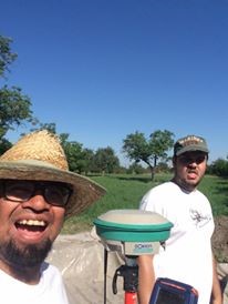
Gergő and yours truly taking a short selfie break with the RTK.
My research project component consisted of talking to residents of the area to find out about the history of the land which is home to the Bronze-Age Cemetery, which the BAKOTA project is excavating. This is important because it gives a sense of how much the soil has been disturbed and whether burials underneath the soil have been disrupted in various ways. In order to conduct the research I was paired with a project partner, Gergő Liptk, a fellow student researcher, local resident of the town of Bekescsaba, and an ace poker player. Together we visited Mr. Pocsaji and Mrs. Hajdu, two residents of the area with deep histories. Gergő provided the crucial component of translation. They gave us important information about the site which I then put into a map and a table while Gergő uncovered pictures and information about the site from old books about the region. Besides this, they provided amazing anecdotes about their lives which delighted the ethnographer and historian in me.

Thanks to the information provided by Mrs. Hajd I was able to mark out the different property boundaries and create a table which expressed their different attributes.
Upon arriving in Hungary I knew little about the country, save that it used to be part of an Empire during the First World War and it was the homeland of the dragon Harry Potter faced in the Tri-Wizard Tournament. I leave with knowledge about the history that is in living memory of Hungarys people through the intimate experiences of some if its residents. Besides providing the land use data the project needs, the information that was given is also providing the story of the land, the people, and the country itself. It demonstrates that archaeology is far more than just the digging component. Hopefully through presenting the research to the local residents, the BAKOTA project can tie the stories of their lives and the land which they and their families have cultivated to the artifacts we are seeking underneath.
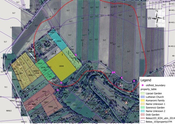
We uncovered that the yellow area was a vineyard, but the light green section wasnt which is why the soil is not as disturbed.